It is important to know that although the Miami-Dade County Water and Sewer Department (WASD) provides potable water and sewer services to City residents, the City of Sweetwater is the entity in charge of the publicly-owned stormwater infrastructure in the City. As part of the Billing of Stormwater Charges commercial property. The money collected by WASD is then returned to the City and used to maintain, operate and improve the stormwater infrastructure including the regional stormwater system of canals and culverts, as well as catch basins, connection piping and french drains on public Rights-of-Way.
Please see the sample Water and Sewer bill statement (2nd page) where you can see the Stormwater Utility charges how they appear in your bill. If you should have any questions regarding these charges, please feel free to contact us at (305) 455-6585 or email pwsubmittals@cityofsweetwater.fl.gov.
What is stormwater?
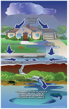
Stormwater is water from precipitation that flows across the ground and pavement due to rain (also called stormwater runoff). The water may seep into the ground, flow in ditches or streams, or enter the storm drain system. The storm drains are what you see at the street corners or at low points on the sides of your streets. The storm drains then lead to a discharge point directly into groundwater or one of the many canals within the City of Sweetwater, groundwaters and eventually to larger water bodies.
Canals have a small amount of relatively clean baseflow that is caused by groundwater recharge and high water tables. In rain events, this baseflow is supplemented by stormwater runoff from impermeable surfaces (impermeable surface do not The Stormwater Utility Department is responsible for the effective and efficient management of the stormwater runoff drainage infrastructure on public right-of-way utility within the City boundaries. As part of the effective management of the system, the Stormwater Utility Department implements various programs to maintain and improve infrastructure. This program includes street sweeping, catch basin and drainage cleanup, canal maintenance, drainage improvements, and new construction to minimize potential flooding. The City developed a Stormwater Master Plan which included design and construction of new stormwater improvements to address flooding issues within the City.
This type of pollution is called nonpoint source (NPS) pollution and is more of a problem than direct discharges from commercial industries plants.
Illicit discharge detection and elimination information
- Guide to Stormwater Pollution Prevention
- Letter to Business Owner
- Letter to Business Owner- Spanish
- Newsletter 2019-2020
- Ordinance #4006
- Pollution under control Stormwater Pollution Prevention
- What is stormwater runoff
- What is stormwater runoff - Spanish
HOW TO PROTECT STORMWATER QUALITY AND DRAINAGE INFRACTRUCTURE….
These are steps that can help us avoid polluting:
- Conserve and recycle resources such as paper, plastic, glass, metals, oils, etc. at your closest recycling center.
- Don't dump hazardous substances such as used oil, household chemicals, yard fertilizers, or other wastes onto pavement, patios or into storm drains.
- Practice street sweeping, picking up litter and disposing of leaves and yard waste.
- Do not dump grass clippings, leaves or branches into the storm drains.
- Prevent excess runoffs of pesticides, fertilizers, and herbicides by using them efficiently.
- Participate in local garbage and debris pickup days and recycle household hazardous materials to prevent storm drain contamination.
- Participate in stormwater protection and public group education on stormwater quality.
- Promote maintenance on private storm drainage systems.
- Remember to always pick up after your pet dispose in a nearby trash can.
MAINTENANCE
Without maintenance, the stormwater drainage system would have a very short useful life. This will result in costly repairs or potential replacement of the whole system and subsequent FLOODING!!!!
Do not treat your drainage system like a garbage disposal. Keep ditches, swales, drainage grates and retention lakes clear of debris, trash, and other discarded material.
Report illegal dumping to the City of Sweetwater Engineering Division at (305) 455-6585, or email us at pwsubmittals@cityofsweetwater.fl.gov. You may also contact Miami-Dade County at 311 or (305) 372-6955.
 Flood Information
During the rainy season, the continuous downpours saturate and, on occasion, over saturate the ground; reducing the capacity of the Storm-water Drainage System. This may cause some temporary flooding along city streets and/or private property, creating potentially dangerous conditions.
 Insurance
Did you know that homeowners and/or windstorm insurance does not cover flood damage to a structure? All property owners should consider purchasing flood insurance.
Flood insurance is available through the City's participation in the National Flood Insurance Program (NFIP). Flood Insurance can be purchased to protect all properties in the City including homes, condominiums, apartments, non-residential buildings, and commercial structures. Due to the City's participation in the Community Rating Service (CRS), you will receive a reduction in the flood insurance premium.
 Why is Flood Hazard Mapping Important?
It is important because it is a part of the National Flood Insurance Program and is used as the basis of the NFIP regulations and flood insurance requirements. FEMA maintains and updates data through the Flood Insurance Rate Maps (FIRMs) and risk assessments. For more information on Flood Hazard Mapping, please visit the FEMA website at www.fema.com or call a Map Specialist in the FEMA Map Information exchange: toll-free, at 1-877-FEMA MAP (1-877-336-2627).
Flood Map Modernization
Flooding causes hundreds of millions of dollars worth of damage to homes and businesses around the country every year. Because standard homeowners and commercial property insurance does not cover floods, the National Flood Insurance Program (NFIP), administered by the Federal Emergency Management Agency (FEMA) was created to offer affordable flood insurance to communities that comply with the development, maintaining drainage systems, and informing the community about flood hazards, insurance, and ways to reduce flood damage. These activities not only benefit the community by improving the quality of life and protecting the environment but, also, save money. Flood insurance is mandatory for property owners who hold a federally backed mortgage and whose property is located within a special flood hazard area (areas designated as having a greater risk of flooding).
On September 11, 2009, the newly revised FIRM's (Flood Insurance Rate Maps) were implemented. The previous maps were older and did not indicate recent changes in development and/or natural changes in the environment. Therefore, these maps were modernized to indicate more accurate data to reflect what flooding hazards exist today on any given property. Modernization of these maps could mean that your property could go from being designated as an SFHA (Special Flood Hazard Zone) or high-risk zone, to a low or moderate - risk area (X-Flood Zone) or vice versa.
Owners of properties that move from a high-risk zone to a low-or moderate-risk zone may be eligible for reduced insurance rates by converting to a Preferred Risk Policy (PRP). A PRP covers both a structure and its contents.
Many people believe that federal assistance is available to cover flood-related damages. This is true, but only when the flooding is declared a federal disaster. Even then, financial aid is usually available in the form of a loan, which must be paid back with interest. Unlike federal disaster aid, flood insurance pays for all covered losses without having the insured having to repay anything. storms, hurricanes, water backup due to inadequate or overloaded drainage systems, a broken sewer line, dam or levee failure, etc. In fact, according to FEMA, in 2006 one in three flood insurance claims come from low-to-moderate risk areas.
For more information about how the new FIRM's affect you, please contact the City of Sweetwater Engineering Division at (305) 455-6585.
Flood Insurance Rate Map (FIRM)
The Department of Homeland Security's Federal Emergency Management Agency (FEMA) has issued a Flood Insurance Rate Map (FIRM). If you have any questions please contact the FEMA Map Assistance Center, toll-free, at 1-877-FEMA MAP (1-877-336-2627) or visit their website at
http://www.fema.gov/plan/prevent/fhm/bfe.
CITY OF SWEETWATER FLOOD INSURANCE RATE MAPS
- Map 12086C0288L-09-11 Panel 288
- Map 12086C0269L-09-11 Panel 269
- Map 12086C0267 Annexation
- Map 12086C02861 Annexation
- Flood Insurance Study
Flood Insurance
Remember, there is a thirty (30) day waiting period before the policy becomes effective. Homeowner's insurance and/or windstorm insurance does not cover flood damage to the structure.
Because the City of Sweetwater is an NFIP community, flood insurance is available to protect all homes, condominiums, apartments and non-residential buildings, including commercial structures within the City. You are eligible for flood insurance, regardless of whether or not your property has ever flooded. All properties secured by a federally backed mortgage (FHA, VA, FNMA, etc.) must carry flood insurance.
Floodplain Development Permit Requirements
All buildings under construction require permits. These permits must be obtained prior to the commencement of construction activities. Contact the Building and Zoning Departments before you build, alter, regrade or fill your property. If you see any building or filling without a permit posted, please call our Code Compliance Department at (305) 221-0411.
Elevation Certificates
Click here to access the Elevation Certificates Search
